Well, we’re about a week into “summer,” though we’ve had hot weather for a long time now. Despite the heat, there will be little air conditioning on today’s trip. So, if you’re not going out in the early morning or the very late afternoon, bring along sunscreen, mosquito repellent and liquids for hydration. When Robert Mills described the village of Newberry in his 1826 Atlas, he said that Newberry was situated in the declivity (downward slope) of a hill. As Newberry grew, it overtook the rest of the hill and several more hills surrounding the original. The crest of the original hill is just a little bit past Boundary Street. The Caldwell-Wright House (originally on the site of the Zach Wright House) is just about on top of the hill, so anything past that point could be considered the other “declivity.” The oldest section of that side of the hill is the Village Cemetery – our destination for this trip. Begin your tour on the Square in historic downtown Newberry.
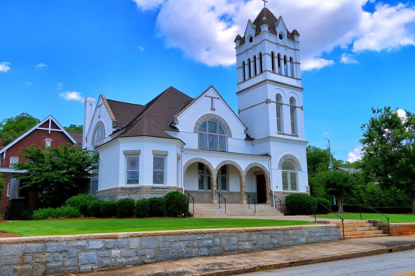
Head south on Caldwell Street. On the east side of Caldwell Street is Central United Methodist Church. Designed by a Tennessee architect named Hunt in 1900, much of the interior decoration was the work of C. C. Davis. A Romanesque style building, Central Methodist is constructed of brick and granite and has beautiful stained glass windows. On the southwest corner of Boundary Street is First Baptist Church. Founded in 1831, it is the oldest congregation downtown. The present Roman style temple-front building was constructed in 1907. One thing that the oldest churches in town have in common is that they do not have churchyard burying grounds adjacent to them. That’s where the Village Cemetery comes into the picture. It was a public burying ground serving the community and the local churches. Turn left on Coate’s Street. An old African-American Church once stood on the corner. It is no longer standing, but several broken monuments to J. J. Whitener, his wife Ogeechee and some of their children survived from its cemetery (which was just below the Village Cemetery). A new marker now commemorates the site of their graves.
On the left is the old Village Cemetery. Begun on one acre of land in 1809, by 1846 it had grown to about five acres. Though few markers remain (the originals were mostly wood) the cemetery was filled by the time Rosemont Cemetery was established in 1863. Pull over and park in the shade of the tree, if you can. In 2011, part of the old cemetery was fenced to protect the remaining monuments and prevent damage to the site from its use as a parking lot for the ball field across the street. Though the lower part of the cemetery (near the turn in Coate’s Street) has a granite ridge which made early burials nearly impossible, it is known that the cemetery extended beyond the range of the present fence. Please remember these unmarked graves with respect. Walk up Coate’s Street to the historical marker and enter the cemetery from that side.
Take care as you walk through the cemetery (any cemetery for that matter) both for your own safety and for that of the broken stones. Remember, also, this is a burying ground and commands a certain amount of respect and reverence. Do not climb on stones. They may look solid, but it doesn’t take much for accidents to occur. Despite the dilapidated condition, the opportunity arises to study how a tombstone is put together. A single stone monument standing upright is called a stele (or stela – it’s a good crossword puzzle clue). Originally these were placed at the head of the grave without any support underneath. Thus older stelae sink over time and are often leaning at odd angles. About 1840, bases were attached to the slabs to make them more stable. A wide stone base, or foundation, is attached to the stele by means of bronze or iron pins. Where stones are broken, these pins or the holes that held them are sometimes visible.
Another early monument type common in this cemetery is called an altar or table tomb. Because of our access to local granite, many of the ones in Newberry are constructed of large blocks or even a single block of stone. Unlike television’s zombie movies, removing the top slab will not reveal a corpse or other remains – these are monuments on top of a burial site. There are enough damaged examples to learn from without vandalizing any more. The Village Cemetery also shows early examples of family plots. The ones here are outlined with brick, granite and iron.
At the entrance to the cemetery is a new monument commemorating those early Newberrians who are buried here but have no markers. Straight ahead is a child’s grave (H. B. Smith who died in 1857). This monument is constructed of a single granite block with a marble slab on top. The iconography on the stone shows a Weeping Willow with an obelisk – a symbol which illustrates that death is natural. Nearby is an adult-sized version made of several granite blocks and a marble slab. According to the signature at the base of the inscription, John H. Carter’s tombstone was made by Boyce and Sprawl of Columbia. Many of the enclosures, especially the brick ones, were built to surround family plots after burial in Rosemont (established in 1863) became more common. Near the northeast corner of the cemetery is the Blease plot which retains part of its wall. The big brick enclosure (which was stabilized a few years ago by re-pointing some of the deteriorated areas) surrounds two marble altar tombs belonging to the Tillery family. Often solid enclosures were placed around graves when the immediate family died off or moved away.
(At the time of this writing, a tree limb was down near the Kinard plot. No damage was done by the limb.) The Kinard monument commemorates several members of the family, including General H. H. Kinard (1806-1869) and Captain John M. Kinard (1833-1864) who was killed at the Battle of Strasburg in Virginia. Nearby is the Ruff Family plot. Its iron gate and granite gateposts are intact, but the brick wall is only survived by its granite capstone. Dr. P. B. Ruff (1801-1890) was a member of the board of directors for the cemetery and was the last recorded burial in the cemetery. The McMorries-Johnston plot has its gateposts and the foundation of brick walls. Notice that the older alter tombs lack a granite foundation which makes them more susceptible to settling and falling apart. There is a fallen stone to William McMorries Brown (died 1855). The stone is signed by C. Smallwood of Newberry. It is decorated by a descending dove – a representation of the Holy Spirit. Just to the east is a monument to Benjamin Saxon (1819-1842). Though he was born in Alabama, he died in Newberry C. H. S. C. (Newberry Court House).
The family enclosure for Kerr Boyce’s wife and children is surrounded by a granite and marble wall with an iron fence and gate. (If you look to the southeast, you can see the spire of the Lutheran Church of the Redeemer.) Nearby is the monument to Joseph Kerr (1797-1823). Featuring a classical pedestal, obelisk and urn, this monument was recently restored. To the south is a new bench which commemorates Edith Greisser (died 2013) who did a lot to help with the saving of this cemetery. The bench overlooks one of her most time-consuming projects – new military markers for 19 soldiers buried in unmarked graves in Village Cemetery. Leave the Village Cemetery and return to the other side of the hill in historic downtown Newberry. A frozen dairy treat may be in order.


