
January : To Saluda And Back
It’s January, and, despite some bursts of warmish weather, the landscape is about as barren as it is going to get. With the deciduous foliage out of the way, this is the best time to look for old road traces, house sites and old family cemeteries. The evergreens are showing off. Camellias are blooming in yards old and new. The foliage of the traditional spring bulbs is beginning to make an appearance.
Begin your tour on the Square in historic downtown Newberry. From the Square turn left on Nance Street and right on Boundary Street. Follow it as it merges into Hwy 121. Stay on Hwy 121 through Deadfall Crossroads. On the left, after Deadfall Road, is the Blair-Boozer House. Its massive double-shouldered chimney marks it as having been built in the early 19th century. Also on the left is the Werts House which was begun in 1896. After Long Farm Road on the left is the site of the Higgins House. The house was later moved to Lake Murray. The Higgins Family operated a ferry across the Saluda River, just south of the present bridge. The Higgins Family cemetery is on the left just after the big pine tree. A recent tree-cutting has made the old cemetery more visible. On the right is the George Hugh Connelly Water Treatment Plant. Built in 1974, this plant treats the water supply for the City of Newberry. It has a capacity of 8.1 million gallons per day. Cross the Saluda River (near the site of Higgins Ferry) into Saluda County.
Saluda is a relatively new county in South Carolina, having split from Edgefield County in 1895. Edgefield County, like Newberry, was established in 1785. The newly-formed county was supposed to be called “Butler” for the prominent family living there, but it was instead named for the river. “Saluda” is derived from an Indian word meaning “river of corn.” It is also the name of an Indian tribe that lived in the area before the Cherokees. Just beyond Hightower Road on the right is the Coleman House with its impressive portico of Ionic columns.
Turn right on Hollywood Road and left on Pine Pleasant Church Road. On the left is another Coleman House, this one with Corinthian columns. Down the road on the right is Pine Pleasant Baptist Church. This old brick church was established in 1831 and has a nice cemetery. Under a canopy built of granite in front of the church is the grave of Luther Rice (1783-1836), a Baptist minister and orator who helped organized the Baptist Church on a national scale and placed an emphasis on foreign missions and education. Continue on down the road. This road follows the old road trace very closely. It gets a bit muddy at times, but it is nothing compared to the high-banked ditch that forms the road trace off to one side.
At the stop sign, turn left on Zoar Road. (On the map this appears as Coleman’s Crossroads.) “Moo” at the cows in the beautiful pastures with the meandering stream. On the left is Zoar Methodist Church. Founded prior to 1830, this was originally called Persimmon Creek Church. In the cemetery are many old tombstones and an unusual grave enclosure. These enclosures over family plots were common in the 18th and 19th centuries, but are rarely seen today. This one has a new tin roof and a picket fence. At the end of the road, turn right on Hwy 121. (On this side of the river it’s called Newberry Hwy.) Cross Big Creek. Coming into Saluda, Pleasant Hill Baptist Church is on the left. Founded in 1871, this African-American church has an unusual tower and an extensive cemetery. Just beyond it are two landmarks at the entrance of town – the large barn that houses the hardware store on the left and the stockyards on the right.
When the county formed in 1895, there was a lot of discussion about the placement of the county seat (though not as drawn out as in Newberry over a century before). The community of Red Bank was chosen, streets were laid out and the town of Saluda was taking shape by 1896. Many of the homes and public buildings reflect the classical revival style popular in the early twentieth century. In the downtown, Hwy 121 becomes N Main Street. Turn left on W Butler Street. On the right is St. Paul’s Methodist Church. Founded in 1898, the present sanctuary was built in 1917. On the right is Ramey Funeral Home which is housed in a turn of the century home. Turn right on N Jennings Street and then left on East Church Street. At the end of the street is Redbank Baptist Church which was founded in 1784. Predating the town by over a century, it was named for nearby Red Bank Creek. The present brick church is the third sanctuary and was built in 1911. It has a portico with Ionic columns, a cupola and a bell tower to side. It has a nice extensive cemetery. Turn around and stay on Church Street.
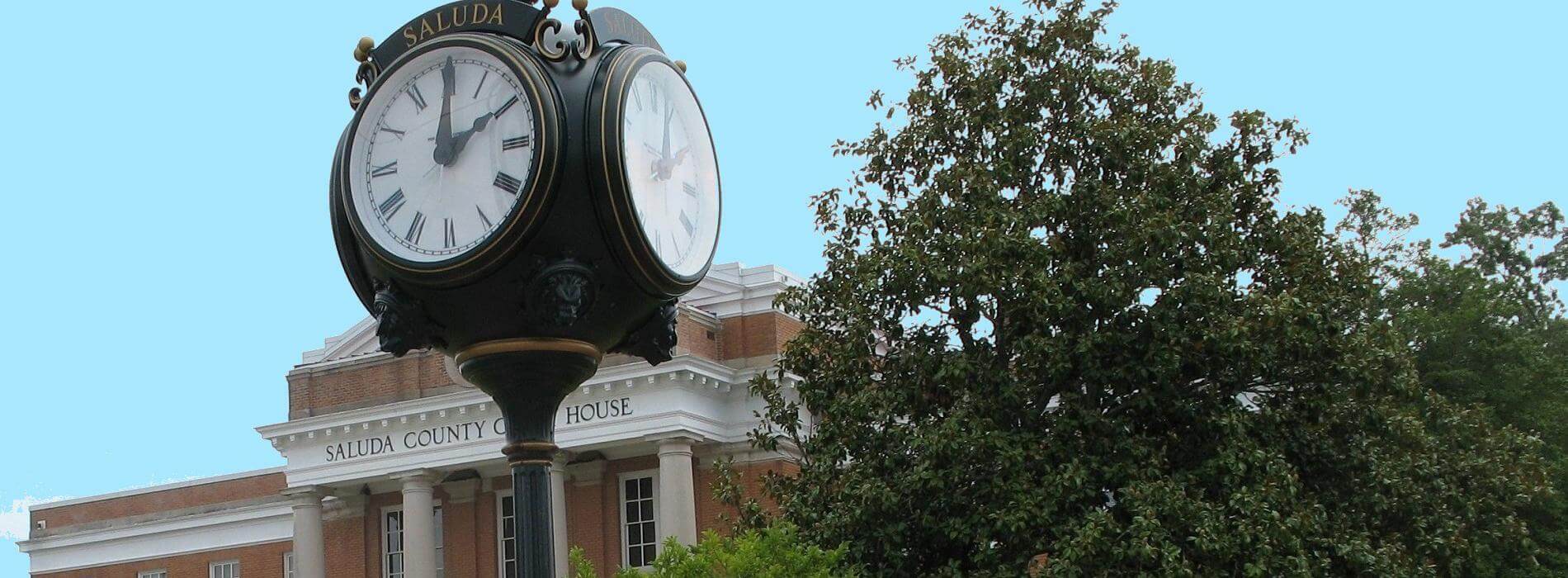
Just before you get to the intersection of Main Street, on the left is the Saluda County Court House on the Square. Next door to the court house is the Saluda Museum in an Art Deco theater. Across Main Street on the right is a mural depicting the Treaty of Old Town in 1755. Turn right on N Calhoun Street. On the left is Mt. Pleasant Lutheran Church. Founded in 1903, the present brick church was begun in 1925 and remodeled in 1963 with new stained glass windows. At the end of the street, turn right on Hwy 178 and then left on Hwy 39 (N Jefferson Street). This is the road leading toward Chappells. A few miles down the road, turn left on Chestnut Hill Road. (There is a church sign and a historical marker right at the road.) On the right is Chestnut Hill Baptist Church which was founded in 1809. In the old cemetery is the grave of Lucinda Horne (Aunt Cindy). She followed her husband and son to Virginia during the War Between the States and was present at many of the major battles in Virginia, West Virginia, Maryland and Pennsylvania. When her son was injured at Richmond she served s a nurse at the hospital in Richmond. After the war, they returned to Edgefield (now Saluda). She died in 1896 at the age of 82. Return to Hwy 39 and turn left.
As you cross the Saluda River back into Newberry County, look to the right to see the remains of the old Main Street for Chappells. Thomas Chaple settled near here in 1756. Later his son operated a ferry at the site which was replaced by a bridge in 1792. The town began as a depot on the Columbia and Greenville Railroad. Following a flood in 1928, the main road was moved about a third of a mile upstream, bypassing the old downtown, which in turn succumbed to a fire in 1940. Turn right on Hwy 34. Turn left on Island Ford Road. The name refers to the old name for Hwy 560 which formed the boundary between Newberry and Laurens Counties. That road is a few miles to the west. What is now called “Island Ford Road” today does not lead to the island ford in the Saluda River, nor does it connect to its counterpart in Greenwood County. Down the road on the left is Crossroads Baptist Church. Organized in 1807, it is an outgrowth of Bush River Baptist Church. The old meeting house is set amid an old cemetery. The drive follows the old road trace. A second road (hence the name of the church) came from the side near the outhouse and does not have a counterpart on today’s map.
Look to the left at the intersection of Old Quarry Road to see the Dr. Peter Moon House which was built in the early nineteenth century. Up the road to the right is Windmill Farm, a typical Newberry County farmhouse of the mid-nineteenth century. Turn right on Silverstreet Road. Turn left on Hwy 34, visit Silverstreet and return to historic downtown Newberry.
Begin your tour on the Square in historic downtown Newberry. From the Square turn left on Nance Street and right on Boundary Street. Follow it as it merges into Hwy 121. Stay on Hwy 121 through Deadfall Crossroads. On the left, after Deadfall Road, is the Blair-Boozer House. Its massive double-shouldered chimney marks it as having been built in the early 19th century. Also on the left is the Werts House which was begun in 1896. After Long Farm Road on the left is the site of the Higgins House. The house was later moved to Lake Murray. The Higgins Family operated a ferry across the Saluda River, just south of the present bridge. The Higgins Family cemetery is on the left just after the big pine tree. A recent tree-cutting has made the old cemetery more visible. On the right is the George Hugh Connelly Water Treatment Plant. Built in 1974, this plant treats the water supply for the City of Newberry. It has a capacity of 8.1 million gallons per day. Cross the Saluda River (near the site of Higgins Ferry) into Saluda County.
Saluda is a relatively new county in South Carolina, having split from Edgefield County in 1895. Edgefield County, like Newberry, was established in 1785. The newly-formed county was supposed to be called “Butler” for the prominent family living there, but it was instead named for the river. “Saluda” is derived from an Indian word meaning “river of corn.” It is also the name of an Indian tribe that lived in the area before the Cherokees. Just beyond Hightower Road on the right is the Coleman House with its impressive portico of Ionic columns.
Turn right on Hollywood Road and left on Pine Pleasant Church Road. On the left is another Coleman House, this one with Corinthian columns. Down the road on the right is Pine Pleasant Baptist Church. This old brick church was established in 1831 and has a nice cemetery. Under a canopy built of granite in front of the church is the grave of Luther Rice (1783-1836), a Baptist minister and orator who helped organized the Baptist Church on a national scale and placed an emphasis on foreign missions and education. Continue on down the road. This road follows the old road trace very closely. It gets a bit muddy at times, but it is nothing compared to the high-banked ditch that forms the road trace off to one side.
At the stop sign, turn left on Zoar Road. (On the map this appears as Coleman’s Crossroads.) “Moo” at the cows in the beautiful pastures with the meandering stream. On the left is Zoar Methodist Church. Founded prior to 1830, this was originally called Persimmon Creek Church. In the cemetery are many old tombstones and an unusual grave enclosure. These enclosures over family plots were common in the 18th and 19th centuries, but are rarely seen today. This one has a new tin roof and a picket fence. At the end of the road, turn right on Hwy 121. (On this side of the river it’s called Newberry Hwy.) Cross Big Creek. Coming into Saluda, Pleasant Hill Baptist Church is on the left. Founded in 1871, this African-American church has an unusual tower and an extensive cemetery. Just beyond it are two landmarks at the entrance of town – the large barn that houses the hardware store on the left and the stockyards on the right.
When the county formed in 1895, there was a lot of discussion about the placement of the county seat (though not as drawn out as in Newberry over a century before). The community of Red Bank was chosen, streets were laid out and the town of Saluda was taking shape by 1896. Many of the homes and public buildings reflect the classical revival style popular in the early twentieth century. In the downtown, Hwy 121 becomes N Main Street. Turn left on W Butler Street. On the right is St. Paul’s Methodist Church. Founded in 1898, the present sanctuary was built in 1917. On the right is Ramey Funeral Home which is housed in a turn of the century home. Turn right on N Jennings Street and then left on East Church Street. At the end of the street is Redbank Baptist Church which was founded in 1784. Predating the town by over a century, it was named for nearby Red Bank Creek. The present brick church is the third sanctuary and was built in 1911. It has a portico with Ionic columns, a cupola and a bell tower to side. It has a nice extensive cemetery. Turn around and stay on Church Street.
Just before you get to the intersection of Main Street, on the left is the Saluda County Court House on the Square. Next door to the court house is the Saluda Museum in an Art Deco theater. Across Main Street on the right is a mural depicting the Treaty of Old Town in 1755. Turn right on N Calhoun Street. On the left is Mt. Pleasant Lutheran Church. Founded in 1903, the present brick church was begun in 1925 and remodeled in 1963 with new stained glass windows. At the end of the street, turn right on Hwy 178 and then left on Hwy 39 (N Jefferson Street). This is the road leading toward Chappells. A few miles down the road, turn left on Chestnut Hill Road. (There is a church sign and a historical marker right at the road.) On the right is Chestnut Hill Baptist Church which was founded in 1809. In the old cemetery is the grave of Lucinda Horne (Aunt Cindy). She followed her husband and son to Virginia during the War Between the States and was present at many of the major battles in Virginia, West Virginia, Maryland and Pennsylvania. When her son was injured at Richmond she served s a nurse at the hospital in Richmond. After the war, they returned to Edgefield (now Saluda). She died in 1896 at the age of 82. Return to Hwy 39 and turn left.
As you cross the Saluda River back into Newberry County, look to the right to see the remains of the old Main Street for Chappells. Thomas Chaple settled near here in 1756. Later his son operated a ferry at the site which was replaced by a bridge in 1792. The town began as a depot on the Columbia and Greenville Railroad. Following a flood in 1928, the main road was moved about a third of a mile upstream, bypassing the old downtown, which in turn succumbed to a fire in 1940. Turn right on Hwy 34. Turn left on Island Ford Road. The name refers to the old name for Hwy 560 which formed the boundary between Newberry and Laurens Counties. That road is a few miles to the west. What is now called “Island Ford Road” today does not lead to the island ford in the Saluda River, nor does it connect to its counterpart in Greenwood County. Down the road on the left is Crossroads Baptist Church. Organized in 1807, it is an outgrowth of Bush River Baptist Church. The old meeting house is set amid an old cemetery. The drive follows the old road trace. A second road (hence the name of the church) came from the side near the outhouse and does not have a counterpart on today’s map.
Look to the left at the intersection of Old Quarry Road to see the Dr. Peter Moon House which was built in the early nineteenth century. Up the road to the right is Windmill Farm, a typical Newberry County farmhouse of the mid-nineteenth century. Turn right on Silverstreet Road. Turn left on Hwy 34, visit Silverstreet and return to historic downtown Newberry.
